Salutation Caravan Park
Location
Where Salutation Caravan Park sits on the map and how to get there.
Nearby cities & towns
Towns and cities closest to Salutation Caravan Park — browse campsites near each.
What’s nearby
Shops, drinking water, fuel and attractions within reach of the site.
🏞️ Attractions

Norham Castle is a castle in Norham, Northumberland, England, overlooking the River Tweed, on the border between England and Scotland. It is a Grade I listed building and a Scheduled Ancient Monument. The castle saw much action during the wars between England and Scotland.


The Ladykirk and Norham Bridge connects Ladykirk in the Borders, Scotland, with Norham in Northumberland, England, across the River Tweed. It is one of three bridges that cross the Tweed along the Anglo-Scottish Border, the others being the Coldstream Bridge and the Union Chain Bridge; out of these, the Ladykirk and Norham Bridge is the youngest, opening to the public in 1888.

Horncliffe is a village in the county of Northumberland, England. It lies on the south bank of the River Tweed about 5 miles (8 km) southwest of Berwick-upon-Tweed, and about 3 miles (5 km) northeast of Norham and is the most northerly village in England.


Roughting Linn ist der Name einer Farm bei Lowick in Northumberland an der B6525 kurz nach dem Abzweig nach Ford. Auf dem Gelände, der nach einem nahe gelegenen Wasserfall benannten Farm, liegt eine der größten und am besten erhaltenen Felsritzungen Nordenglands mit Cup-and-Ring-Markierungen. Die Kuppe aus Sandstein ist etwa 20 m lang und 12 m breit. Der westliche Rand ist durch einen bis zum Jahr
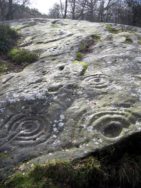
Roughting Linn ist der Name einer Farm bei Lowick in Northumberland an der B6525 kurz nach dem Abzweig nach Ford. Auf dem Gelände, der nach einem nahe gelegenen Wasserfall benannten Farm, liegt eine der größten und am besten erhaltenen Felsritzungen Nordenglands mit Cup-and-Ring-Markierungen. Die Kuppe aus Sandstein ist etwa 20 m lang und 12 m breit. Der westliche Rand ist durch einen bis zum Jahr
🛒 Amenities & services
🛒 Groceries
- Norham Shop
- Thisselcockrig Farm Shop
- Etal Post Office
⛽ Fuel
 Tesco
Tesco Asda
Asda Shell
Shell
🍽️ Food & drink
- The Victoria Hotel
- The Mason's Arms
- The Fishers Arms
➕ Medical
- Norham Surgery
- Pharmacy
- Tweedmouth Pharmacy
🚰 Drinking water
- Drinking water
🚻 Toilets & showers
- Public toilets
🎾 Sports
- Tennis
- Pedwell
- Place de la Petanque
🏧 ATM & bank
 Bank of Scotland
 RBS
RBS- Yorkshire Building Society
Weather
Current conditions and the forecast to help you plan your trip.
Best time to visit
Typical monthly temperature and rainfall at Salutation Caravan Park.
Reviews
Ratings, nightly prices and photos from people who’ve camped here.
No reviews yet — be the first!
Other campgrounds nearby
More places to camp close to Salutation Caravan Park.