Schreiershaven
Camping Brielse Meer (via site)
Location
Where Schreiershaven sits on the map and how to get there.
Nearby cities & towns
Towns and cities closest to Schreiershaven — browse campsites near each.
What’s nearby
Shops, drinking water, fuel and attractions within reach of the site.
🏞️ Attractions
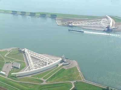
The Maeslantkering 'Maeslant barrier' is a storm surge barrier on the Nieuwe Waterweg, in South Holland, Netherlands. It was constructed from 1991 to 1997. As part of the Delta Works, the barrier responds to water level predictions calculated by a centralized computer system called BOS. It automatically closes when Rotterdam, especially the Port of Rotterdam, is threatened with flooding. Maeslantk
🛒 Amenities & services
🛒 Groceries
 Jumbo
Jumbo Albert Heijn
 Lidl
Lidl
⛽ Fuel
 Esso Express Brielle
- DCB Energy Maasvlakte
 Shell
Shell
🍽️ Food & drink
- Paviljoen De Kogeloven
- Oriental Fusion
- Gasterij De Bollaarshoeve
➕ Medical
- Medisch Centrum Brielle
- Apotheek Medisch Centrum Brielle
- Huisartsenpraktijk De Kok
🚻 Toilets & showers
- Public toilets
🎾 Sports
- Fitland Brielle
- Sportcomplex Dukdalf
- Tafeltennisvereniging De Sprint/DPD
🏧 ATM & bank
 ATM
ATM- Geldmaat
 ASN Bank
Weather
Current conditions and the forecast to help you plan your trip.
Best time to visit
Typical monthly temperature and rainfall at Schreiershaven.
Reviews
Ratings, nightly prices and photos from people who’ve camped here.
No reviews yet — be the first!
Other campgrounds nearby
More places to camp close to Schreiershaven.
- Modjo-Kerto
- De Lepelaar · Nederlandse Caravan Club
- Veld 13
- Camping de Meeuw
- Veld 12
- De Krabbeplaat