The Butts Reserve
Location
Where The Butts Reserve sits on the map and how to get there.
Nearby cities & towns
Towns and cities closest to The Butts Reserve — browse campsites near each.
What’s nearby
Shops, drinking water, fuel and attractions within reach of the site.
🏞️ Attractions
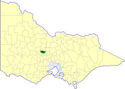
The Shire of Maldon was a local government area about 140 kilometres (87 mi) northwest of Melbourne, the state capital of Victoria, Australia, and 35 kilometres (22 mi) southwest of the regional city of Bendigo. The shire covered an area of 549 square kilometres (212.0 sq mi), and existed from 1858 until 1995.

🛒 Amenities & services
🛒 Groceries
 IGA
⛽ Fuel
 Robert Cox Motors: BP
🍽️ Food & drink
- Bbq
- Kangaroo Hotel
- Maldon Hotel
➕ Medical
- Maldon Hospital
🚰 Drinking water
- Drinking water
🚻 Toilets & showers
- Public toilets
🎾 Sports
- Pétanque
- Maldon Golf Course
- Maldon Bowls Club
🏧 ATM & bank
- Bendigo Bank
Weather
Current conditions and the forecast to help you plan your trip.
Best time to visit
Typical monthly temperature and rainfall at The Butts Reserve.
Reviews
Ratings, nightly prices and photos from people who’ve camped here.
No reviews yet — be the first!
Other campgrounds nearby
More places to camp close to The Butts Reserve.