Thompson Creek Campground
Location
Where Thompson Creek Campground sits on the map and how to get there.
What’s nearby
Shops, drinking water, fuel and attractions within reach of the site.
🏞️ Attractions
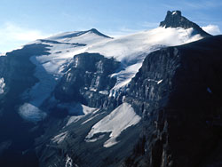
Resolute Mountain is located in David Thompson Country, western Alberta, Canada, 12 km north of Saskatchewan River Crossing. Its line parent is Mount Cline located 2 kilometres to the east.

The Mistaya River is a short river in western Alberta, Canada. It flows through Banff National Park in the Canadian Rockies, and a section of the Icefields Parkway was built along its course. Mistaya River originates in Peyto Lake, a glacial lake of typical blue colour (due to rock flour). Mistaya flows north-west, receiving the waters of creeks such as Delta, Silverhorn, Cirque, Noyes, Chephren,
🛒 Amenities & services
⛽ Fuel
- The Crossing Resort
🍽️ Food & drink
- Parkway Pub
- The Crossing Cafe
🚻 Toilets & showers
- Public toilets
Weather
Current conditions and the forecast to help you plan your trip.
Best time to visit
Typical monthly temperature and rainfall at Thompson Creek Campground.
Reviews
Ratings, nightly prices and photos from people who’ve camped here.
No reviews yet — be the first!
Other campgrounds nearby
More places to camp close to Thompson Creek Campground.
- Waterfall Creek Campground · Alberta Forest Service
- Waterfowl Lakes Campground · Parks Canada
- Cavalcade Group Campground · Province of Alberta
- Silverhorn Creek Campground · Parks Canada
- Preacher's North Rustic Camping Area
- Preacher's North Rustic Camping Area